Challenges in Mapping the Digital Divide
The divide between those who had access to broadband and those who did not was highlighted during the pandemic as society and commerce moved from in-person to digital services. This included everything from working from home, school, and health care services to delivery of services from, for example, grocery stores and restaurants.
The federal government has been working for many years to decrease the number of Americans who lack broadband access. Part of the effort relies on using maps of who has broadband access and who doesn’t. Today’s WatchBlog post looks at our new report on the Federal Communication Commission’s efforts to map the digital divide, and the challenges this effort faces.
Messed-up mapping?
FCC has a goal of providing broadband access to all Americans. Its Universal Service Fund is the largest of its programs designed to achieve this goal—providing funding for schools, libraries, rural health care providers, low-income consumers, and those in rural and high-cost areas to gain internet services.
To identify areas that need broadband access, the Universal Service Fund relies on maps of internet accessibility based on data collected from broadband providers. However, this data is not always accurate. For example, some rural areas with low populations are lumped together, and may appear to have access when they do not. This is because providers may report the entire area as having broadband even if only one location has service. The result of this mapping error is that resources to improve internet access do not always match the need.
To get more precise assessments, Congress approved the Broadband DATA Act in 2020. This required FCC to create a better map starting with getting more granular data on the precise locations of homes, businesses, and other places that could make use of broadband. Once this location map is complete, FCC will overlay broadband providers’ service area data to show which locations are served and which are not.
Challenges in developing a more useful map
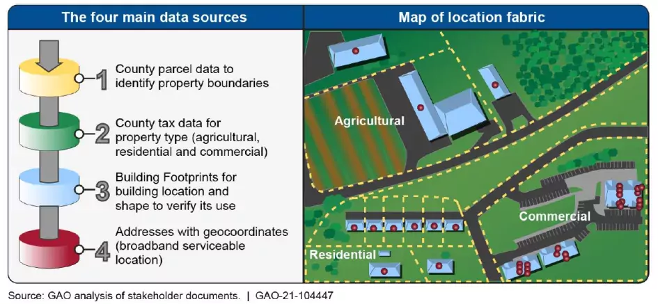
In our new report, we looked at the first stage of FCC’s efforts to create a publicly accessible, nationwide map that shows specific locations in the U.S. that could be served by broadband. We found that FCC’s effort faces a number of challenges. For example, there is no single dataset sufficient for developing a comprehensive map. There are however, 4 sources of data that could be combined to create a more comprehensive map of locations. These sources are:
- Parcel data. Parcel data is a dataset typically collected and maintained at the local government level. It shows property boundaries and is useful for determining which structures or property may need broadband.
- County property tax assessor data. Information about the property taxes and use of a property, such as whether it is residential, agricultural, or commercial, can help verify broadband access needs.
- Building footprints. Renderings of the base of building structures—imagery taken from orbiting satellites or aerial craft—may be useful for determining the type of building and whether or not it is likely to require broadband service or not.
- Address data. Mail delivery addresses can be used to locate specific residences and businesses and associate them with broadband serviceable locations.
Image

Next steps
Initially, the map will not contain data on individual’s or businesses’ access—only on locations. Once the map is completed, providers’ data on where they have deployed broadband can be added to show which locations have access and which do not. FCC has met with data companies and states to learn from their location map development efforts. Additionally, FCC officials said they will have a process to incorporate state, local, and tribal entities' feedback on the map—anyone can challenge data they believe are inaccurate—and to correct any errors.
- Comments on GAO’s WatchBlog? Contact blog@gao.gov.
GAO Contacts
Related Products

GAO's mission is to provide Congress with fact-based, nonpartisan information that can help improve federal government performance and ensure accountability for the benefit of the American people. GAO launched its WatchBlog in January, 2014, as part of its continuing effort to reach its audiences—Congress and the American people—where they are currently looking for information.
The blog format allows GAO to provide a little more context about its work than it can offer on its other social media platforms. Posts will tie GAO work to current events and the news; show how GAO’s work is affecting agencies or legislation; highlight reports, testimonies, and issue areas where GAO does work; and provide information about GAO itself, among other things.
Please send any feedback on GAO's WatchBlog to blog@gao.gov.


